

Mr Muhammad Hamza Tanvir is an independent journalist and a political analyst, focusing primarily on regional and global strategic and political issues. He has authored numerous articles for different national and international publications.
Introduction
A strait is a natural, narrow waterway that is typically navigable, connecting two larger water bodies, seas, or oceans. They are mostly formed by tectonic shifts such as the Strait of Gibraltar. Some straits are unnavigable because of being too shallow. Straits can also be used as a source to generate tidal power using turbines and the Larantuka Strait of Indonesia is one example of such. Listed below are some of the famous straits of the world.
Strait of Malacca
According to the United Nations Conference on Trade and Development (UNCTAD), 60 percent of the maritime trade by volume passes through Asia, and the South China Sea carries about one-third of the global shipping. This route relies on the Strait of Malacca as it connects the South China Sea and the Pacific Ocean to the Indian Ocean.
This route holds much importance to Japan, Taiwan, South Korea, and especially China – China’s economic security is highly associated with this route as it is the 2nd largest economy in the world. Roughly, 100000 vessels pass through this strait each year which makes almost 40% of the global trade.

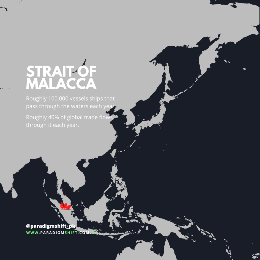
One of the nine famous straits of the world, the Strait of Malacca runs between Malaysia, Singapore, and Indonesia, and has been a major gateway for trade. Its strategic significance has made it a source of the international rift from the 15th century to the present day. The inauguration of the Suez Canal in 1869 increased its importance as it became the main link between the Indian and Pacific Oceans. It is serving as the main transit route for supplying essential commodities to fuel the fast-growing economies of Asia and other regions.
This narrow path of water could easily be choked by the rival nations of China which could be highly inimical for the big industrial country. Singapore plays a key role in this regard as it is an ally of the archrivals of China – India and the United States. This creates a security dilemma for China as its rivals can influence Singapore to block this path. If this happens, it could slow down the “China Dream”.
Strait of Hormuz
The Strait of Hormuz lies between Iran and Oman, linking the Arabian Sea and the Gulf countries (Bahrain, Iraq, Saudi Arabia, Kuwait, the United Arab Emirates, and Qatar). The shipping lanes in both directions are merely 3km wide, while the narrowest point in this strait is only 33km wide. It provides the single most important oil passage of the globe that forms a chokepoint between the Gulf of Oman and the Arabian Gulf.
This 39km long stretch is the single route to the open ocean for more than 1/3rd of the globe’s Liquified Natural Gas (LNG) and 1/6th of the world’s oil production. This strait is the only way to transport goods to the rest of the world by the waterway from Gulf countries. That is why Saudi Arabia and the UAE have repeatedly proposed to build more oil pipelines to avoid this problematic strait as they have hostile relations with Iran.
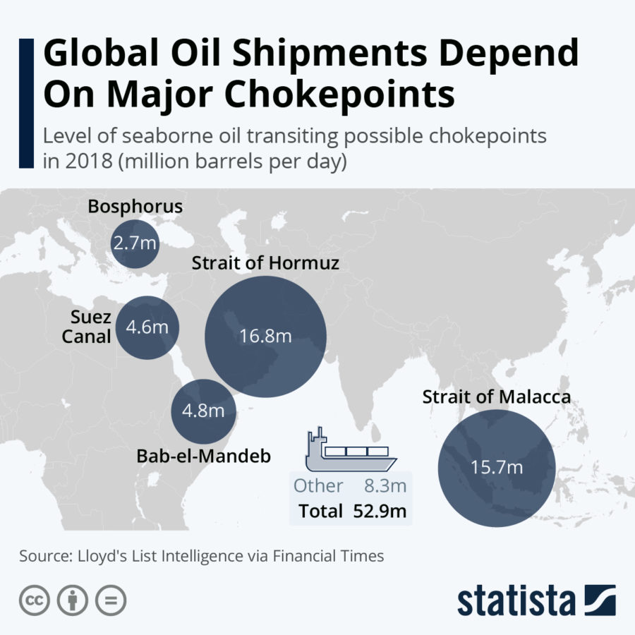
Most of the oil from the Organization of Petroleum Exporting Countries (OPEC) members is transported through this strait which stands almost at 17.2 million barrels per day. The world’s biggest LNG exporter, Qatar, transports most of its LNG through this waterway. Although the US’s fifth fleet, which is based in Bahrain, is responsible for the protection of the maritime shipping lanes, there have been multiple incidents of attacks on the ships travelling from this strait.
Four vessels, including 2 Saudi oil tankers, were attacked just beyond this strait near Fujairah in May 2019. In June 2019, two oil tankers were also attacked in the Gulf of Oman which raised questions on the security of the global oil supply and other shipments through the Strait of Hormuz.
Strait of Gibraltar
The Strait of Gibraltar, also known as Estrecho de Gibraltar in Spanish, is strategically located between the northwestern part of the African continent and the southern part of the continent of Europe. The Strait is positioned between the British Overseas Territory of Gibraltar and Spain in the north, and by the Spanish exclave of Ceuta and Morocco in the south.
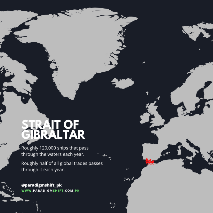
The length of the strait is about 59km, while its width is about 13 km at its narrowest point, which is located between Spain’s Cape Marroqui and Morocco’s Point Cires. The Western end of this strait is about 43km wide. The Eastern end of the strait which is located between the Mount of Hacho or Jebel Moussa in the south and the Rock of Gibraltar in the north is about 23km wide.
These 2 features of the strait’s land are regarded as the Pillars of Heracles. The depth of this strait ranges from 300 to 900m and forms an important gulf between the Atlas Mountains of Northern Africa and the high plateau of Spain.
Strait of Djibouti
The Bab el-Mandeb or the Strait of Djibouti is strategically a chokepoint between Yemen and Djibouti that links the Red Sea to the Arabian Sea and the Gulf of Aden. This strait is also known as the “Gate of Tears”. Bab el-Mandeb is segregated into 2 channels by Perim Island. Larger ships use the deeper and wider western channel which is around 25km wide at its narrowest point and 310 meters deep.
The smaller one is two miles wide and is located along the Yemeni coast. It is only 8 miles at its narrowest point. Exports from Asia and the Persian Gulf to the Western markets have to cross this strait before passing through the Suez Canal. It is a geopolitically contested strait which makes it the most dangerous strait in the world.
Most of the exports of natural gas and petroleum from the Persian Gulf that pass the Suez Canal have to cross this strait to reach their destined location. The Gulf countries rely heavily on this strait for the transport of their oil. More than 21000 oil vessels pass through this strait per year and almost 57 oil vessels pass each day.
Saudi Arabia alone sent 600000 barrels a day of crude oil to its buyers in North America and Europe in 2018. 330000 barrels of oil a day were transported additionally to its Red Sea port of Yanbu from its main export facility at Ras Tanura. 120000 barrels a day also went from Yanbu to Asia.
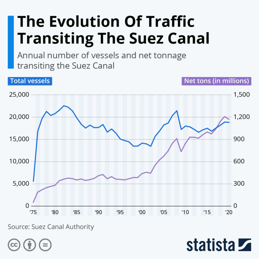
Suez Canal
This artificial waterway in Egypt links the Red Sea and the Mediterranean Sea. Its strategic significance has been immense ever since its construction in 1869. The 163km-long strait is located in the west of the Sinai Desert Peninsula. The canal provides a direct path between the northern Indian oceans and the North Atlantic via Red Seas and the Mediterranean.
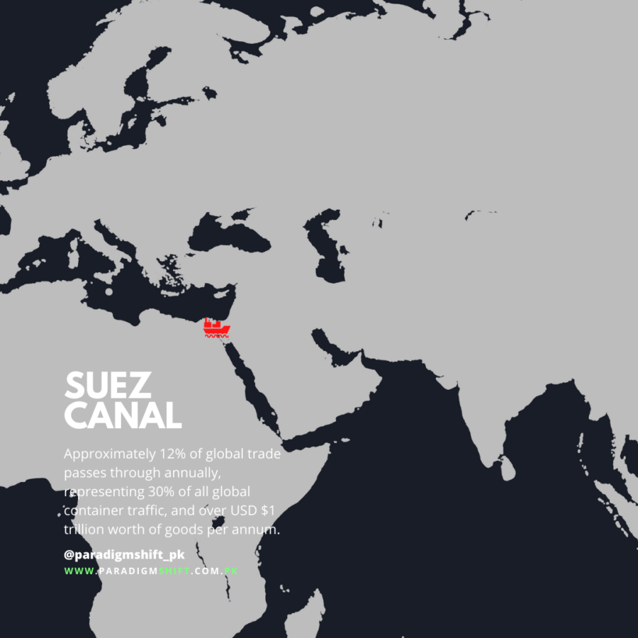
It is considered to be the shortest link between the west and the east, as compared to the Cape of Good Hope, because of its peculiar geographic location. The importance of this strait is burgeoning with the evolution of world trade and maritime transport. Maritime transport is considered to be the cheapest mode of transportation. This route helps in saving time, fuel, and ship operation costs.
The significance of this canal can be gauged from the fact that the recent six-day blockade of the Suez Canal resulted in a $90 million loss in toll revenue to the Egyptian government as scores of ships waited to cross the waterway or took alternate ways. The blockage restrained about $10 billion of cargo a day from passing through the strait. About 12% of global trade passes through this strait annually, representing 30% of all global container traffic, and more than $1 trillion of goods per annum.
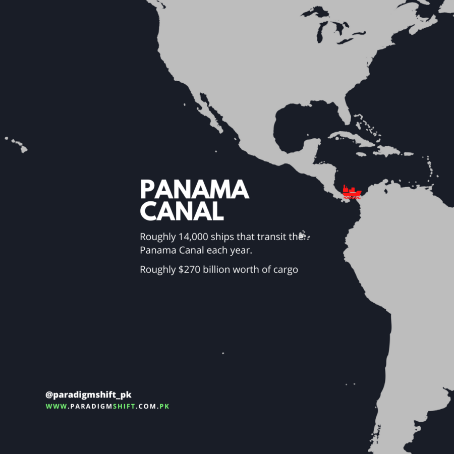
Panama Canal
The Panama Canal is also one of the famous straits of the world located inside Panama and is an artificial waterway that connects the Pacific Ocean and the Atlantic Ocean. Its construction is deemed to be the biggest and toughest engineering project in history. The idea of constructing a waterway across Panama dates back to the 1500s when King Charles 1 of Spain ordered his regional governor to survey the route along the River Chagres.
At that time, this idea seemed unrealistic due to the mountainous and jungle-like terrain, but the idea remained in mind since then. France was the first country to attempt to construct the canal, but it failed due to incessant rains that led to landslides. The US purchased French assets in the canal zone in 1902. This proposed canal was in Colombian territory at that time.
The US put its military weight behind the Panama Independence Movement. On 6th November 1903, the US recognized Panama as an independent state, and the Hay-Bunau-Varilla Treaty was signed with the new state which granted the US permanent and exclusive possession of the Panama Zone. In return for this treaty, Panama secured $10 million and an annual amount of $250000 which began 9 years later.
The Canal was officially inaugurated on 15th August 1914 and was completed at a cost of $350 million. The transition of the canal to local oversight was initiated in 1977 when a treaty was signed between the Panama leader Omar Torrijos and the US President Jimmy Carter which led to the assumption of complete control over the canal by the Panama Canal Authority on December 31, 1999.
The canal was recognized as one of the seven wonders of the world by the American Society of Civil Engineers. It hosted its 1 millionth ship in September 2010. Roughly, 14000 vessels transit the Panama Canal annually, carrying around $270 billion worth of cargo.
Turkish Straits
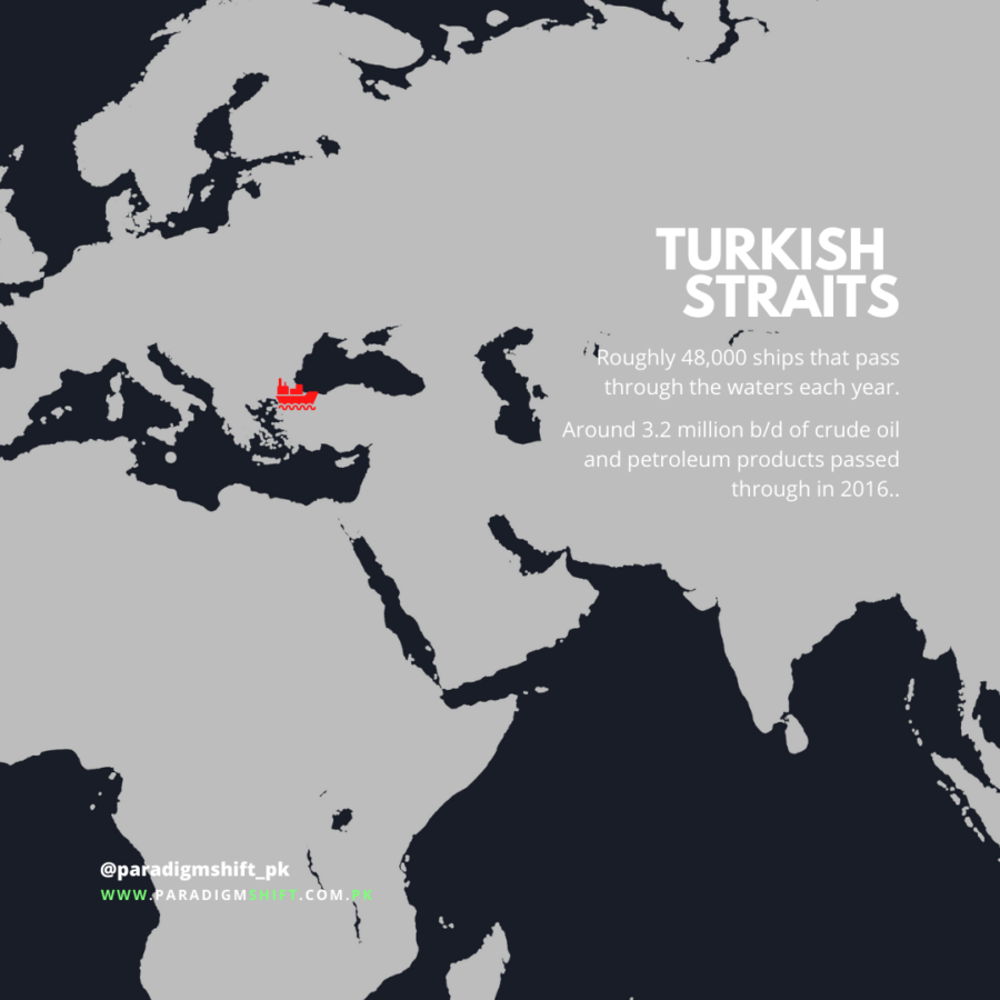
Bosphorus Strait, also known as the Strait of Istanbul, is a natural strait that connects the Black Sea to the Sea of Marmara and is located in northwestern Turkey. It links the Asian part of the country with the European part. In maritime trade, the Bosphorus Strait has played a major role. The length of this strait is 32 km and the width is 730-3,300 meters, with a depth of 30-120 meters. Roughly, 48,000 ships pass through the Turkish Straits every year. About 2.4 million barrels of oil pass through the Bosphorus every day.
Bering Strait
The Bering Strait is a significant water passage between the westernmost point of North America and the easternmost point of Asia which divides Alaska and Russia. It marks the boundary of Asia and North America and is named after the famous Danish explorer Vitus Bering. It provides the only marine gateway between the Pacific Ocean and the icy Arctic. The strait is merely 55 miles wide at its narrowest point and is replete with wildlife.
Every spring, one of the biggest wildlife migrations of wildlife pass through this narrow strait to set foot in the Arctic. The increasing sea traffic is casting damaging impacts on the marine life of the strait. It is home to several species that are adapted to its environment. The traffic through the Bering Strait augmented around 150% between 2008 and 2018. The ship traffic in the US Arctic waters could expand by a third by the year 2030.
Danish Straits
The Danish Straits are a series of channels that provide a link between the North Sea and the Baltic Sea, and separate Greenland and Iceland. It is a significant route for the Russian seaborne exports of oil to Europe. Roughly, 3.3 million barrels of oil per day flowed through these regions in 2013. As per the EIA estimates, 42% of all the oil transported through these straits originated from the Russian port of Primorsk in 2013.
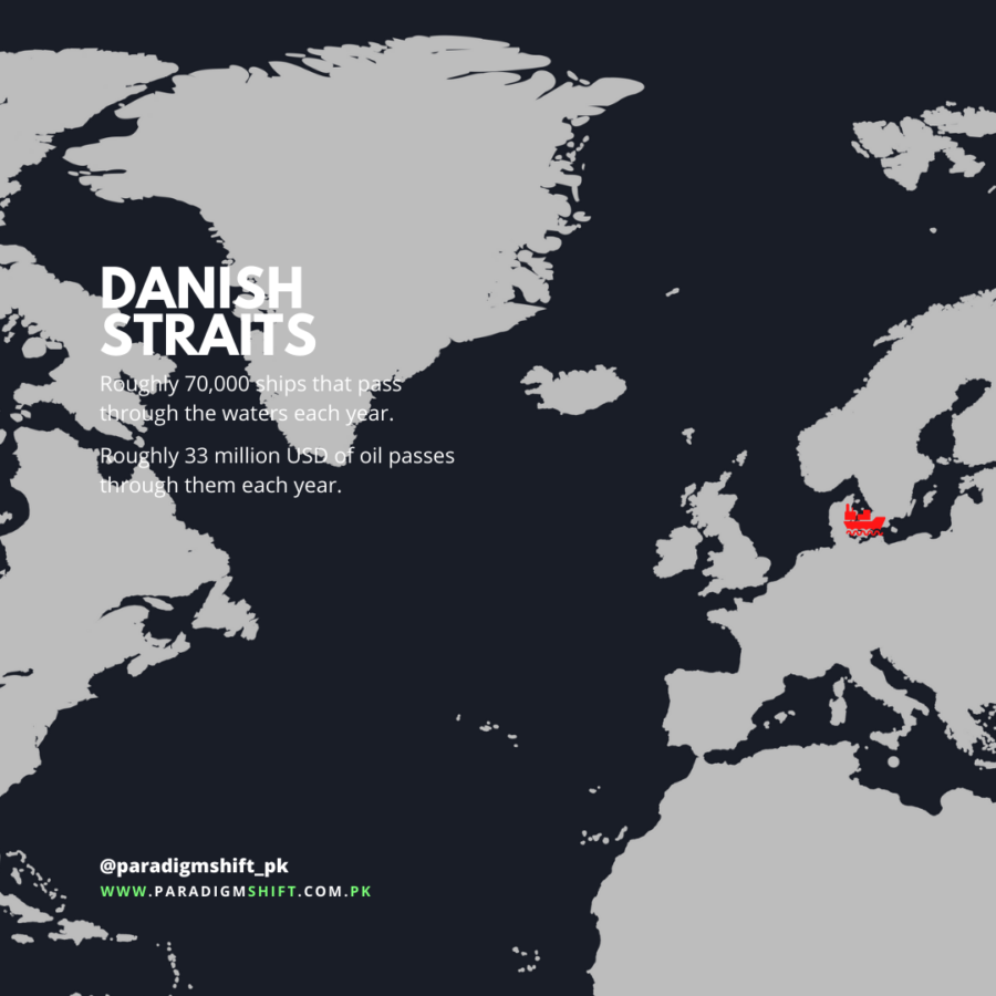
A trivial amount of British and Norwegian oil also passes through these straits, but Russia will be the most affected country if the straits are ever blocked. Approximately, 70,000 ships pass through the waterways annually, and in 2016 alone, 3.2 million barrels of crude oil passed through the Danish Straits each day.
If you want to submit your articles and/or research papers, please check the Submissions page.
The views and opinions expressed in this article/paper are the author’s own and do not necessarily reflect the editorial position of Paradigm Shift.


")


