
Navigation in History
Long before treaties like the UN Convention on the Law of the Sea (UNCLOS) were needed, water navigation existed as the art and science of efficiently steering a ship. From requiring skill to avoid possible dangers to having mathematical, oceanographic, and physical knowledge, water navigation encompasses all aspects of seafaring. Not only does it require the understanding to use any instrument or landmarks for navigation, but it also requires awareness of all related agreements for safe traveling. It includes basic knowledge and understanding of visual clues, visible not only on the map but the ship’s surroundings too, for a safe and accurate journey.
The history of navigation dates back to thousands of years. The earliest navigators used piloting as one of their methods to steer their ships between distant ports by familiarizing themselves with the sequences of intervening landmarks. Navigation in early times also served as a preliminary sign of exploration through water. While navigators would prefer movement only according to landmarks, sometimes, they would explore more passageways, leading to the discovery of more lands.
In Western civilization, the Phoenicians are known to be the first generation to develop the art of navigation. Their sailors used primitive charts and comprehended directions by observing the sun and stars for movement over the sea. The civilization stands as the nascent symbol of instrument development for navigation overseas.
Despite these early beginnings, it took many centuries for global navigation at sea to become possible. It was not until the 18th century that further ventures on sea began to take place with the help of developing methods and tools for navigation. Historians tend to divide early navigation into 3 phases.
Antiquity
This era included the development of sea navigation with the use of birds, stars, waves, swells, sounding weights, etc. to detect nearby lands. Moreover, their distinctive feature was using songs and mythological stories to help people remember important navigational information.
Medieval
The medieval era included the use of sunstone, celestial navigation, portolan charts, quadrant astronomy, and the development of extensive maps, etc. for navigation. This era also marks the beginning of outspreading trade networks with the help of water navigation to enhance trade links with other regions.
Age of Exploration
The era marked an extensive development, beginning in almost all domains of water navigation. While states increased agreement over water control around their coastline, they also started participating in marine navigation to discover more areas. Thus, this period marked the discovery of Porto Santo Island (near Madeira) in 1418, the re-discovery of the Azores in 1427, the discovery of the Cape Verde Islands in 1447, and Sierra Leone in 1462.
From the 18th century onwards, marine navigation saw a revolutionized system of navigation that was led by the development of instruments that could help in better movement over the seas.
United Nations Convention on the Law of the Sea (UNCLOS)
Over time, there have been numerous bilateral or multilateral treaties signed by states to resolve their water-related issues. The treaties address issues ranging from water quantity division, control over water canals, navigation, regulating the division of water resources, etc.
Correspondingly, the first-ever legal agreement signed in history was also linked with water contention. It dates back to around 2500 BC, when the two Sumerian city-states of Lagash and Umma crafted an agreement ending a water dispute along the Tigris River. It also saw a third party as a regulator. King Mesilim, the head of Kish—a kingdom that held a hegemonic position over loosely allied Sumerian city-states—played the role of the regulator.
UNCLOS serves as the first kind of international water-related agreement that 167 countries have ratified, according to the latest statistics. Adopted formally in 1982, the convention serves as the main introduction to the national rights and responsibilities of states over the sea and provides a legal framework for all marine and maritime activities.
Why was UNCLOS Needed?
Different reasons highlight why an international treaty over sea navigation came into existence. The first reason behind the UN Convention on the Law of the Sea was the principle of “freedom of the seas,” according to which state power over coastal waters extended to 3 nautical miles. This principle was introduced by the imperialist powers, who maintained that the maximum distance a cannon shot could travel from a shore would fall under the state’s jurisdiction. However, this changed after World War II, when 12 nautical miles were accepted as the limit of national power over sea.
The second reason behind UNCLOS was the extension of national claims. At the beginning of the 20th century, states started extending their national claims over water bodies with the motive of protecting fish stocks and working against pollution. This resulted in many states having more control over the sea than they systematically should. Additionally, under international customary law to protect natural resources, states started extending their control over the sea.
Such an event was first recorded by President Harry S. Truman in 1945, when he extended American control to all the natural resources of the US continental shelf. After the US, three other nations—Chile, Ecuador, and Peru—followed suit and extended their rights on the water body to 200 nautical miles (370 km) to cover the Humboldt Current fishing grounds. Right after that, other nations extended their water territories to 12 nautical miles (22 km) from the coastline.
Additionally, after World War II, many states gained independence as a result of decolonization, further complicating the system vis a vis enhancing the competition for natural resources.
What does UNCLOS Say?
The UN Convention on the Law of the Sea formulated a legal framework for different matters related to the high seas. It was concluded in three phases.
| Phases | Year | Decision | Outcome |
|---|---|---|---|
| UNCLOS I | Concluded in 1958 | Agreements reached over four treaties | 1. Convention on the Territorial Sea and Contiguous Zone 2. Convention on the Continental Shelf 3. Convention on the High Seas 4. Convention on Fishing and Conservation of Living Resources of the High Seas. |
| UNCLOS II | Concluded in 1960 | No agreement | Scholars analyzed the underrepresentation of underdeveloped and developing states as one of the main reasons for no agreement. |
| UNCLOS III | Between 1973 and 1982 | Legal framework made | Covered archipelagic status and transit regimes, exclusive economic zones (EEZs), continental shelf jurisdiction, deep seabed mining, the exploitation regime, protection of the marine environment, and settlement of maritime disputes per international law. |
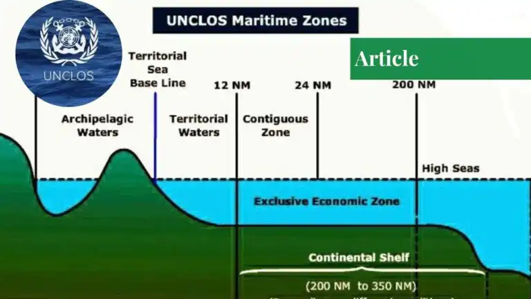
Under UNCLOS, the concept of national rights of states over the seas is strictly divided from the part coming under the international waters. The internal waters concept was introduced as the landward side from the baseline which is completely under the sovereign rule of the state. From the baseline of the coastal state, up to 12 nautical miles in the high seas were set to be considered as the territorial sea in which the coastal state has the sovereignty to apply laws. However, states are also limited with the order of provision of innocent passage to vessels that do not pose any existential or security threat to the state.
From the territorial sea, an additional 12 nautical mile area comes under the state which is a borderland that divides the territorial sea from mainland international waters. Here, states do not have complete sovereignty to regulate the sea but they can work in this area in four different domains: customs, taxation, immigration, and pollution. This area is called the contiguous zone.
Additionally, states also have access to exclusive economic zones (EEZs), a concept introduced by the UNCLOS that extends coastal states’ right to exploitation over natural resources up to 200 nautical miles from the baseline. The law also introduced the idea of an archipelagic state, a country that consists of one or more archipelagos. Such states have their legal rights over all the parts it constitute and thus, the domain of water in between these archipelagos is almost considered internal waters.The UN Convention on the Law of the Sea approved 5 states as archipelagic states including The Bahamas, Fiji, Papua New Guinea, Indonesia, and the Philippines.
Furthermore, UNCLOS has also introduced provisions for the landlocked states to receive freedom of transit through the transit states with the help of bilateral agreements. Article 127 of the UN Convention on the Law of the Sea also frees the landlocked states’ vessels in transit to enjoy freedom from customs.
Additionally, while ships with the flag of landlocked states should be treated the same as other foreign ships, UNCLOS also gives the responsibility to landlocked states to help transit states construct and improve means of transport when needed. Correspondingly the UNCLOS also constitutes many other treaties for the protection of the sea and laws to manage sea mining and other natural resources.
Limitations of the UN Convention on the Law of Sea
One of the major limitations that UNCLOS has itself imposed is the complete sovereignty of states over as much as 350nm in which the coastal states can do whatever they want. Due to this, many states are freely doing deep sea mining and exploiting the sea to extract natural resources for their benefit, which in turn adds to pollution as well as the extinction of many resources and marine animals.
Moreover, the UN Convention on the Law of the Sea cannot regulate its laws completely over the states as many powerful states are involved in contention and conflict by manipulating the concept of EEZs and the continental shelf. The dispute over the South China Sea has brought to light how Chinese claims cannot be undone by the UNCLOS body.
The convention has also failed to provide any solution to states producing artificial islands to enhance their national rights over the sea. The law has majorly failed to protect the marine environment and, with the introduction of EEZs for uninhabited islands, major states have achieved a key subsidy to exploit and benefit from it.
If you want to submit your articles and/or research papers, please check the Submissions page.
The views and opinions expressed in this article/paper are the author’s own and do not necessarily reflect the editorial position of Paradigm Shift.

Sabrina Sohail is a student of National Defense University, Islamabad.