Introduction
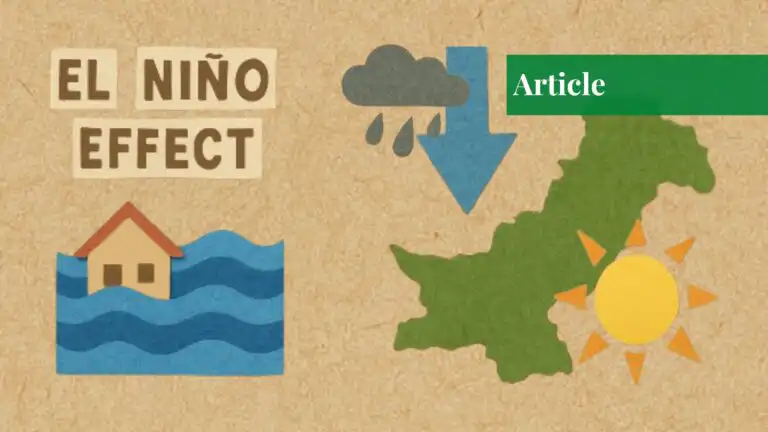
Climate change is drastically restructuring the weather patterns globally, and the brunt of it is being shared, particularly by South Asia, and especially Pakistan. The ENSO phenomenon, comprised of El Niño and La Niña effects, is amplifying climate variability, making extreme weather events even worse, leaving Pakistan with an unpredictable future. Over the next 2-7 years, as exacerbated by El Niño, Pakistan’s vulnerabilities will deepen, jeopardizing not only food and agricultural stability but also water and disaster resiliency.

Current Situation in South Asia
Over the years, El Niño conditions have been known to bring both warmer temperatures and lower monsoon rainfall in South Asia. Pakistan, already home to unpredictable weather, is now challenged by waves, prolonged droughts, and sudden floods. The 2022 floods, caused by climate-driven glacier melting and heavy rainfall, only underscored how vulnerable the country is to hydrometeorological disasters. And, coupled with an agriculture-dependent economy, Pakistan requires stable climate patterns for stability, but current trends show growing instability.
Climate Change Devastations in Pakistan
Agricultural Impact
Pakistan’s farming-based economy, the country’s foundation, faces big risks from climate change. Less rain and extreme heat make it hard for crops to grow wheat, rice, and maize, which feed millions. Long dry periods mess up planting times and hurt soil health, causing lower yields. On the other hand, sudden floods and water-clogged fields, often due to weird weather, damage large farm areas. This pushes farmers out of work and disrupts the farming schedule, starting a chain reaction on food output and costs, and in the end, making food harder to get for many people.
Water Scarcity
Pakistan faces a looming water crisis made worse by climate change. Lower snowpack over the mountains and glaciers thawing at a faster pace threaten water flow in the river systems like the Indus, which supports much of the country’s irrigation and hydropower, along with the socio-economic circles. This disturbed water availability impacts farming, drinking water, and energy production. Adding to this problem, the overuse of groundwater is draining aquifers, too. This double challenge of less surface water and shrinking groundwater makes water scarce, putting both city and rural people at risk of shortages.
Disasters and Infrastructure Damage
Climate disasters keep hitting Pakistan hard, damaging its key structures. Floods, dry spells, and bursting glacier lakes cause big problems. These events force millions to leave their homes, wreck houses, schools, and hospitals, and make rebuilding much more expensive. Floods tear up roads, bridges, and phone lines, cutting off areas that need help. At the same time, cities face more danger from extreme heat, which can make people very sick without good cooling systems. These issues show we need stronger buildings and better ways to handle disasters right away.
Food Security Challenges
With the population rapidly reaching the 224 million mark, Pakistan has started to face severe food deficit problems. Previously, the revenue record explained that imports have significantly increased, rising from $4.7 billion in 2020 to $7.4 billion in 2023, which shows that Pakistan is becoming more dependent on other regions of the world and lacks self-sufficiency. Amidst all of this, there are ongoing climate change events like droughts alongside irregular rainfall and temperature patterns, leading to fertile land becoming unproductive and useless.
All of these issues make it increasingly harder for farmers to adapt, which is disrupting traditional cropping patterns. Major crops like wheat, rice, and maize, which are central to feeding millions of people, are being targeted. The over-exploitation of soil leads to a further loss of fertility, which makes management interventions hard to achieve. Not only does this hinder the economy, but it also exposes Pakistan to extremely volatile international prices and supply chain disruptions. Without the introduction of aid in innovation, agriculture, or water management, it is safe to say that food security issues will only keep worsening.
Pakistan is prone to various hydrometeorological hazards, including:
- Floods
- Droughts
- GLOFs
- Heatwaves
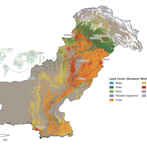
GIS and Remote Sensing in Mitigation
Yield Estimation
Geographical information systems (GIS) and remote sensing (RS) technologies revolutionize agricultural monitoring and governance. Through RS equipment, satellite images, and spectral analysis, crop health, growth stages, and stress levels provide significant data. For example, vegetation indices such as the Normalized Difference Vegetation Index (NDVI) enable accurate evaluation of crops, identifying areas affected by drought, insects, or disease. Initial detection of these stress factors allows timely intervention, such as targeted watering, fertilizer application, or pest control. In addition, RS technologies support the weather patterns, earth health data, and historical crop benefits, and support forecast models, providing decision-makers and farmers with potential insight to reduce the potential decline.
Hazard Mapping
GIS equipment is indispensable to identify and map climate-sprouted hazards such as floods, droughts, and high-risk areas such as heat waves. By combining spatial data sets, altitude models, and hydrological data, the provided can indicate flood-exposed areas and imitate the expansion of potential floods under individual rainfall scenarios. Similarly, drought mapping of climate data and soil moisture indices is used to identify the risk of long-term droughts. Heatwave-exposed areas can also be mapped by analyzing ground surface temperature and urban heating effects. These dangerous maps are important for developing input-based disaster preparation schemes to reduce target resource allocation, initial warning systems, and loss of life and property.

Water Resource Management
Skilled water management is important in climate areas such as Pakistan, and RS technologies provide equipment to monitor and adapt water resources. Satellite images, such as Landsat or Sentinel missions, track glacier dynamics, reservoir levels, and high-temporary river flow. This information helps manage reservoirs to plan water accessibility and irrigation plans and to avoid both deficiency and surplus. Advanced radar systems, such as Sentinel-1 and GPM (global rainfall) satellites, provide insight into the depth and rainfall velocity, especially capable of accurate water resource schemes in areas that depend on the season’s snowmelt.
Decision Support Systems
Integrated GIS-based platforms are required to make real-time decisions in climate adaptation and disaster management. These systems add different data sets, including satellite images, weather forecasts, and socio-economic data, to create dynamic and interactive maps and models. These decision-making platforms can be used to imagine current trends, follow future scenarios, and assess weaknesses in different fields. For example, a GIS-based decision support system may model the effect of an adjacent El Niño event and predict rain deviations and their effect on agriculture, water accessibility, and diastral risk. These tools improve coordination among stakeholders, streamline resource distribution, and enable evidence-based policy, which strengthens the flexibility of climate change.
| Parameter | 2022 Observations | 2025 Projections | 2030 Projections |
| Land Surface Temp. (MODIS) | 28°C (avg summer) | 450 mm (average monsoon) | 400 mm (average monsoon) |
| Rainfall (TRMM/GPM) | 28°C (average summer) | 450 mm (avg monsoon) | 400 mm (avg monsoon) |
| Humidity (%) | 30°C (average summer) | 58% (average annual) | 55% (average annual) |

| Year | Precipitation (mm) | Humidity (%) | Temperature (°C) |
| 2023 | 600 | 62 | 29 |
| 2025 | 580 | 60 | 30 |
| 2030 | 550 | 57 | 31 |

Mitigation and Way Forward
Agricultural Resilience
To ensure agricultural flexibility ahead of climate change, it is important to introduce drought-resistant crop variants. These crops are raging to bloom in an engineered or chosen low aquatic environment, which reduces the dependence on unexpected rainfall. Modern watering techniques, such as drip and sprinkler systems, ensure water-competent agriculture by reducing evaporation and runoff.
Climate-smart agriculture practices, such as AWD, ridge sowing, crop rotation, intercropping, and integrated insect handling, increase the soil’s fertility and reduce the risk associated with monoculture. Grants for inputs such as certified seeds, fertilizers, and accurate agricultural equipment for small users ensure similar access to resources and encourage employees who adopt measures to be adopted widely. These strategies protect overall food security and stabilize agricultural revenues.
Water Management
Effective water management and water conservation are crucial to mitigate the effects of climate change on water resources. As water resources are the lifeline of Pakistan, currently. Water conservation infrastructure, such as dams, reservoirs, aquifers, wetlands, and rainwater harvesting systems, helps store extra water under heavy rainfall during the drought season. Groundwater extraction is required to prevent an aquifer’s lack of aquifer and can be achieved through political reforms and technology such as intelligent meters. Encouraging effective use of water involves the promotion of micro-director systems and water recovery techniques in urban and agricultural sectors. Remote sensing (RS) can be used to monitor river flow and reservoir level and provide information for resource allocation and permanent water management.
Disaster Preparedness
Strengthening disaster preparation involves taking advantage of the geographical information system (GIS) and remote sensing (RS) to develop strong initial warning systems. These systems can provide real-time alerts for floods, droughts, and other hydro-season hazards by analyzing satellite data and future predictive models. Increasing programs with society-based disaster risk reduction ensures that the locals are trained and equipped to respond to emergencies.
Building resilient infrastructure, such as elevated shelters and flood-resistant housing, reduces further weaknesses. Including landscape-based disaster simulation in the plan enables active measures, which reduce the socio-economic effects of disasters.
Policy and Governance
An adaptive political framework is required to address climate risk that prefers long-term flexibility. This involves preparing national and provincial climate adaptation strategies that correspond to international agreements such as the Paris Accord. Politics should adopt renewable energy and encourage permanent land use and conservation practices. Integration of climate ideas into development plans ensures that infrastructure, health care, and education systems are flexible for climate effects. Regular political reviews and consultation with stakeholders ensure that strategies remain dynamic and effective against developing climate challenges. Strong surveillance mechanisms supported by GIS data enable decision-makers to assess progress and assess the initiative as needed.
International Collaboration
International cooperation provides access to the Global Climate Change Fund, such as green climate funds and global environmental facilities, which can finance adaptation projects on a large scale. Technical assistance from international organizations can help implement advanced technologies such as climate-flexible infrastructure and renewable energy systems. Cooperative research initiatives with global institutions can increase the understanding of regional climate and inform evidence-based policy. Participating in international forums strengthens Pakistan’s voice to advocate for fair resource distribution and share knowledge. Restriction agreements and collaborative disaster plans for disasters lead to regional flexibility for shared climate challenges.
The effects of El Niño are an imminent challenge to the environment, economy, and society of Pakistan. Through the effective use of GIS and RS technologies, Pakistan can reduce losses, increase food security, and build a permanent future. Active measures and long-term plans are important to ensure that the country can benefit from the changing climate and reduce the destruction caused by the dangers of the hydro season.
If you want to submit your articles and/or research papers, please visit the Submissions page.
To stay updated with the latest jobs, CSS news, internships, scholarships, and current affairs articles, join our Community Forum!
The views and opinions expressed in this article/paper are the author’s own and do not necessarily reflect the editorial position of Paradigm Shift.

Mansoor Tariq Khattak is a native of Shakardara, Kohat. Professionally, he is serving as an assistant director in Geographic Information Systems (GIS) at the Board of Revenue (BoR) in Khyber Pakhtunkhwa (KPK). Additionally, he is pursuing his Ph.D. in remote sensing and GIS from the prestigious Punjab University, Lahore.